CONNECT - local COastal moNitoriNg sErviCe for PorTugal


Summary


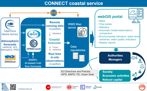
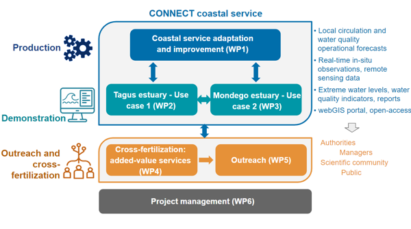
CONNECT delivers a local, high-resolution, coastal monitoring service that seamlessly integrates model-based forecasts and observations to provide blue (physical) and green (biogeochemical) data on Portuguese estuaries to the Copernicus Marine Service (CMEMS).

This service integrates two recent operational coastal data infrastructures: the UBEST coastal observatory and the CoastNet monitoring infrastructure.

CONNECT's main features are: i) shelf-to-estuary, high-resolution, circulation and water quality operational modeling, downscaling CMEMS regional forecasts to produce daily forecasts of physical and biogeochemical variables; ii) real-time physical and biogeochemical data acquisition from in-situ observation networks, and remote sensing data from CMEMS; iii) a dedicated WebGIS portal, providing web services and open access to the data and related physical and water quality indicators, and iv) seamless integration with CMEMS regional models and Earth Observation (EO) data.

The new integrated service will strengthen the support of the implementation of the Water Framework Directive (WFD), the Marine Strategy Framework Directive (MSFD), the Floods Directive (FD), and other EU policies, such as the Green Deal, by providing further and integrated historical and real-time information on physics and biogeochemistry.

CONNECT coastal service

CONNECT coastal service


Project


CONNECT will deliver a user-friendly service that seamlessly integrates and shares through a dedicated webGIS portal layers of blue and green data, aggregated at different spatial and temporal levels. The integrated service will be globally accessible, comprehensive, flexible, and modular, being easily customizable and transferable to other coastal systems anywhere. The service’s main features are:

  • Shelf-to-estuary, high-resolution, circulation and water quality operational modeling with SCHISM operated by WIFF and OPENCoastS, downscaling CMEMS regional forecasts to produce daily forecasts of local physical and biogeochemical variables;
  • Real-time physical and biogeochemical data acquisition from in-situ observation networks, and EO-based data from CMEMS (CoastNet);
  • River flows at the models’ upstream boundaries predicted using Artificial Intelligence (AI);
  • Automatic model-observations comparison, enhancing confidence in both;
  • Water level extremes and water quality indicators based on model forecasts and observations;
  • Weekly reports of the modeled and observed variables that summarize both the physical behavior and the water quality status of the coastal systems;
  • A dedicated webGIS portal, providing web services and open access to the data;
  • Seamless integration with CMEMS regional models and EO data.


CONNECT coastal service
Implementation of project

Results


Use Case 1 - Extreme water levels and water quality in the Tagus estuary. Learn more

Publications


Coming soon

Events


Demonstration session "Sessão de demonstração do serviço CONNECT – Caso de uso #1, Estuário do Tejo". Agenda

1. CONNECT project and Tagus estuary case study (in Portuguese)
2. Observation network (in Portuguese)
3. Circulation and water quality forecast systems (in Portuguese)
4. Demonstration of the CONNECT webGIS portal (in Portuguese)

Consortium


Partners

Logo dos Parceiros

Logo dos Parceiros

Team
LNEC: Marta Rodrigues (coordinator), André B. Fortunato, Alphonse Nahon, Anabela Oliveira, Gonçalo Jesus, Ricardo Martins, Elsa Alves

Faculdade de Ciências da Universidade de Lisboa Laboratório Nacional de Engenharia Civil FCUL-FCID: Ana C. Brito, José Lino Costa, Bernardo Quintella, Paula Chaínho, Susana França

Contacts


Marta Rodrigues

(+351) 218 443 613

Laboratório Nacional de Engenharia Civil
Av. do Brasil, 101
1700-066 LISBOA
PORTUGAL


This work has been carried out as part of the Copernicus Marine Service CONNECT project. Copernicus Marine Service is implemented by Mercator Ocean in the framework of a delegation agreement with the European Union.